
Whilst the last week has been totally focused on covering distance, there has been a surprising amount to see. Many other campers we have met have talked with dread or boredom about much of the route we have just covered, we would disagree with them and have been much entertained by what we have seen.
Esperance in the South West corner of Western Australia (Sunday night / Monday morning) (England won the ashes Sunday night) is famous for having sent the American space agency a littering fine when part of the Skylab space station fell within their Shire (the Americans paid up). It is also famous for a wonderful costal drive, which even when seen in the pouring rain is quite spectacular.

and a set of rocks which have a passing resemblance to an animal

Sam – can you guess what animal this looks like? Papa Paul took a video of one swimming under water. James - (turtle or tortoise).
The distance from Esperance to Cocklebiddy (Monday night / Tuesday morning) is 642 kms and includes the longest straight section of road in Australia.

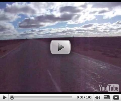
At Norseman, our SatNav told us to go straight ahead for the next two days or until we had covered 1197 kms (748 miles) and then turn left, a rather uncomplicated set of navigational instructions! The first 2000 kms of the landscape enroute has either been scrub forest

or has been less than that. The video below shows what you can see around when on the straight section – not a lot but quite interesting in itself.
The sense of isolation is quite strong and the number of vehicles we have passed has been surprisingly low when you consider that there is no other road across the bottom of Australia. Roadhouses of course make the most of passing trade and fuel costs at least 25% more when you refuel on the way (as you have to do) compared to that at petrol stations at either end of the route.

Cocklebiddy to Nullarbour (468 kms) provides proof that it is not wise to drive at night. About 1 hour into the day, we come across a car which had hit a kangaroo at 1930 the previous night. The collision made a hole in the

radiator and the driver was stranded there all night until he could see what was wrong and how it might be repaired in daylight the following day. He was hopeful of making a repair, if only to avoid the towing charges which

would be significant. The only help he wanted was water, so off we set again. Had the accident been serious, then medical help is some distance away. Some roadhouses are home to an ambulance (as at Cocklebiddy) and

there are sections of road which also double up as airstrips – we

have encountered one every 100 kms or so over the past few days. Perhaps the difficulty of getting immediate medical help explains the number of roadside memorial crosses we have seen.
One can off course stop off for a game of golf along the way. The Nullabor has its own golf green with tees every 10 kms or so – this is the tee at Eucla

the mascot for the Roadhouse proclaiming the distance to London as being 17,517 kms

and also the only chapel attached to a Roadhouse we have seen.

Further on, we stayed at a Roadhouse where you could land your plane, refuel at the pumps and then carry on.

Towards the end of the Nullabor plain, there is a place called The Head of Bight where during the Australian winter, Southern Right Whales come to

give birth. When we went there, there were more whales beneath us than we could count, some breaching, others sleeping, some doing a tail wave, others with their calves. At one point, we counted at least 15 whales, many with calves, they were so close to the bottom of the cliffs that you could hear them breathing.

There are at least four whales close together in this picture

Mother and calf

Two whales
Nullabor Road House to Streaky Bay (418 kms). This is a relatively boring

the mascot of the road house
section, a very flat plain which stretched for miles then gradually gives way to gain fields which also stretch for miles. Eventually one reaches Ceduna for a “Fruit Fly Inspection” and then on into the Eyre Peninsula.
So, although we are at least 800 kms from Adelaide, we have driven across the bottom of Australia and conquered the Nullabor Plain which we found more interesting than we had been led to believe. The early pioneers had to cross it in wagons like that below – thank goodness we had a van.

Streak Bay is a small town on the western side of the Eyre Peninsula. We were allocated a pitch which was adjacent to the beach and so for the first

time ever, we could sit in our van and see directly onto the beach and the sea. Because of this and also because it had stopped raining, we changed our plans and stayed there two nights and dropped the idea of going down to Port Lincoln at the tip of the Peninsula.
On the way to Cape Bauer to see the whistling caves and the blowholes, we passed a 20 cm long Goanna (aka Bob-tailed goanna, Blue Tongued Lizard) – not very remarkable you may think but

when we were in Kakadu, one of the night time lectures included details of the mega-beasts which roamed Australia thousands of years ago and a 7 metre long version of this was quite common. Although relatively harmless, it was not afraid to hiss and open its mouth threateningly at the photographer.
The Whistling Rocks and Blow Holes at Cape Bauer turned out to be one of the most exciting sights we have seen on this trip. We heard about them by chance from other couple and found them after a 16km drive down a dirt track.
In summary, at the point on the coast the Southern Ocean rolls in with tremendous force and enormous waves. Over the millennia, blowholes have been created in the Limestone rocks at the Cape together with small holes or pipes through the rock from the base of the cliffs to the top. When

the waves hit the cliffs, they force water up through the holes and air up

through the pipes creating a combination of water spouts and whistling
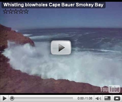
noises plus enormous crashing waves. A viewing platform right on the cliff edge provides the ideal place to stand and be amazed.
30 kms away are Murphy's Haystacks – giant chunks of rock either free standing or sticking up out of the hill top. Murphy’s because they are on

land once owned by Mr Murphy and Haystacks because someone thought that is what they were when he saw them from a distance.
The road from Streaky Bay to Port Augusta (393 kms) passes through unending cereal fields, the town of Kimba which marks the fact that it is half-way between the East and West Coasts with a giant Galah

and then enters Iron Ore areas (the town of Iron Knob features large) until one gets to the foothills of the Flinders Range. At this point, Adelaide is a few hundred kms down the road.
Port Augusta also marked the end of sunshine (four whole days without rain) and just as we were about to set off to see the “Australia Arid Lands Desert Park”, it poured with rain! overlooked by the Flinders Ranges, the

park is home to numerous plants, all well laid out and many with descriptions and explanations, including the fact that the Spinefex is also

called the “Kangaroo Bed” because Kangaroos like to sleep on it.
No comments:
Post a Comment